
GPS & GIS Utility Mapping

Paint Fades. The Map Doesn't.

Field markings last until the next rain, the next grading pass, or the next crew. A GPS-referenced utility map turns a one-day locate into a permanent site record your team, your engineer, and the next contractor can all work from.
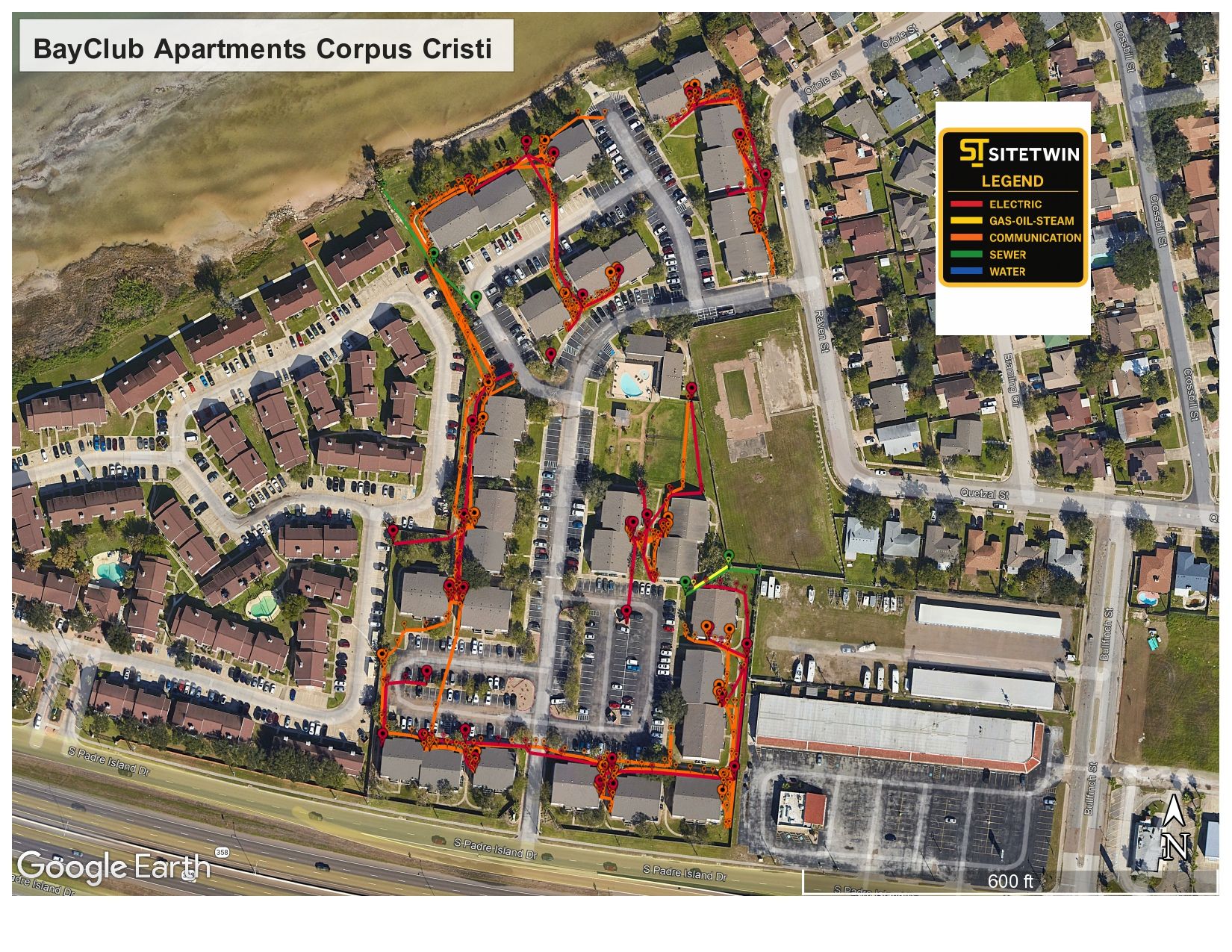
SiteTwin utility map deliverable overlaid on an aerial of a Texas apartment complex
You Leave With a FilePDF and KMZ, not just marks on the ground
GPS LoggedSub-meter field collection
PDF + KMZStandard deliverables
CAD ReadyFormats your engineer can use
Same-day or next-day mobilization
PDF maps & KMZ deliverables included
Private utility locating beyond 811 coverage
Why Mapping Matters

The locate is the fieldwork. The map is the asset.

Every locate produces information. Most of it disappears when the paint does. If nobody captured position data, the next crew on that site starts from zero and pays for the same locate again.

We collect utility positions with GPS as the locate runs, then deliver them as a georeferenced map. That file drops into Google Earth, sits under a civil design, and gets handed to the next trade without anyone re-tracing lines in the dirt.

  • PDF exhibit for the field and the office
  • KMZ for Google Earth and mobile field use
  • Color-coded by utility type with a legend
  • Tied to real coordinates, not a sketch over a screenshot
  • Reusable on the next phase of the same site
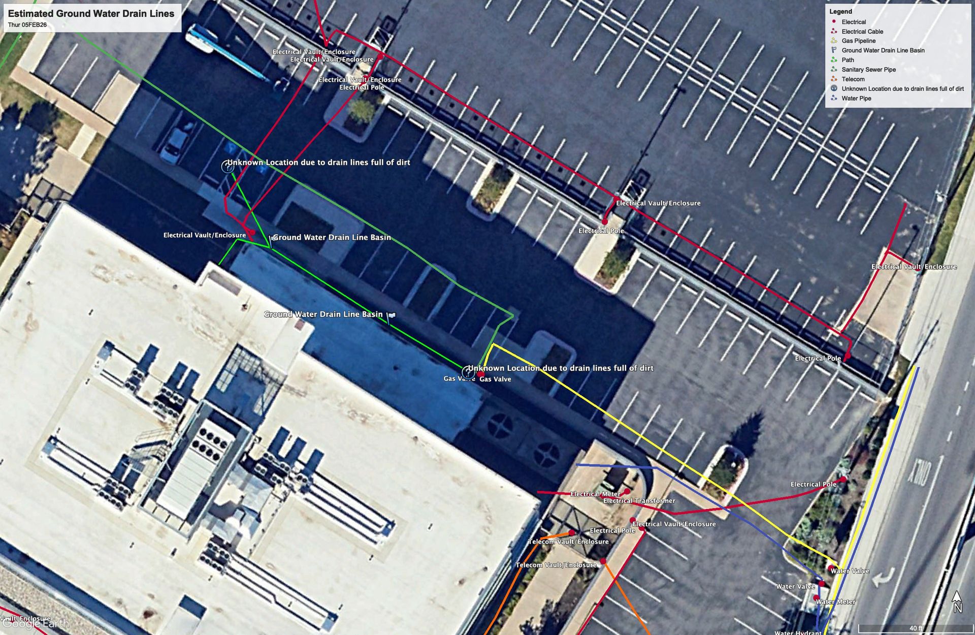
Georeferenced utility map showing color-coded underground lines over a site aerial
What You Receive

Deliverables Built to Be Handed Off

The point of a map is that somebody else can use it later without calling us to explain it.

PDF Site Exhibit

A scaled, legible plan view with a legend, suitable for submittals, coordination meetings, and printing for the field.

KMZ / Google Earth

Open the site on a phone or laptop and see located utilities on the aerial, which is how most field crews actually want it.

Coordinate Data

Point and line data referenced to real coordinates so your surveyor or engineer can bring it into their own workflow.

Documentation

A locate nobody recorded is a locate you buy twice.

Georeferenced deliverables mean the work survives the weather, the schedule, and the crew change.

Send the Address & Scope
How It Runs

How Field Work Becomes a File

Mapping is not a separate visit. It happens while the locate is running.

1

Locate the Utilities

EM and GPR passes identify and trace what is underground across the defined work area.

2

Collect Position in the Field

As lines are traced they are logged with GPS, so position is captured at the moment of the locate rather than reconstructed later.

3

Build the Map

Field data is drafted into a color-coded utility map with a legend, checked against site photos and field notes.

4

Deliver in Usable Formats

You receive the PDF exhibit and KMZ, plus coordinate data when your team needs to bring it into CAD or GIS.

EM+GPR
Dual-method locating on every scope
PDF/KMZ
Maps & GPS data included
5 Metros
Austin, Dallas, Houston, Fort Worth, San Antonio
5.0★
Average Google review rating
Common Questions

Utility Mapping Questions

Is mapping included or is it an add-on?
PDF and KMZ deliverables are included with our locating work. If you need a specific format, a particular coordinate system, or CAD-ready data, tell us up front so we collect it correctly the first time.
What is the difference between a utility map and a survey?
A survey is performed by a licensed surveyor and carries a different standard of accuracy and liability. Our mapping documents located utility positions with GPS for planning, coordination, and design support.
Can you deliver in a specific coordinate system?
Tell us the coordinate system and datum your project uses before we mobilize and we will collect and deliver in it.
Will the map show utilities you could not find?
The map shows what was located and it notes areas where coverage was limited. Congested areas, deep lines, non-conductive pipe, and inaccessible ground all get flagged rather than quietly omitted.
Can we reuse the map on the next phase?
That is the main reason to have one. A georeferenced file stays useful across phases, trades, and contractors on the same site.
Do you map utilities inside buildings or under slabs?
Concrete scanning documents what is inside and beneath a slab. That work can be delivered alongside site mapping so the interior and exterior sit in the same record.

Need the locate documented, not just marked?

Send the address and tell us what formats your team works in.

Send the Address & Scope
Get in Touch

Ready to get your site mapped?

Send the address and scope, plus the file formats and coordinate system your project uses. We will confirm what we can deliver before we mobilize.

Austin, TX & statewide Texas coverage
PDF and KMZ included as standard
Coordinate data available on request